



Mars Xplorer

Mars Xplorer açıklaması
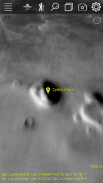
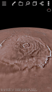
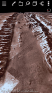
Join the fun! This application lets you view the terrain of the planet mars in 3D. Data from NASA and USGS combined with Deep Learning Artificial Intelligence Swarm works together to give you the best real experience and extend your smart phone capabilities. The AI is new and can detect structures on the surface. The default color layer shown is 323m/pixel but there is a higher resolution radar grey 100m/pixel. It allows you to zoom down to the surface and roam around like a rover. You can fly over interesting areas using our "Trek" capability. You can quickly create your own custom Treks anywhere on Mars fly over them and save them for use anytime! You can select one of our GPS Tracks or add your own then fly over automatically using that track selecting your altitude and rate. Lists of locations on the planet are available from us or you enter and zoom to the longitude/latitude you enter. Multiple layers of terrain information can be overlapped and transparency control for each layer is provided.
It is best to use an internet connection through a WiFi router and we tested with 2GB of CPU Memory and large pixel count but it might be okay with 1GB and low pixel resolution but not with 500MB of CPU Memory. We support Android 5.1+.
Eğlenceye katıl! Bu uygulama 3D gezegen Mars arazisini görüntülemenizi sağlar. Derin Öğrenme Yapay Zeka Swarm ile kombine NASA ve USGS verileri size en iyi gerçek deneyimi sunmak ve akıllı telefon özelliklerini genişletmek için birlikte çalışır. AI yeni ve yüzeyde yapıları tespit edebilir. gösterilen varsayılan renk tabakası 323m / piksel ama daha yüksek bir çözünürlük radar gri 100m / piksel var. Bu yüzeye aşağı yakınlaştırmak Gezici gibi etrafında dolaşmak için izin verir. Bizim "Trek" yeteneği kullanarak ilginç alanları üzerinde uçabilir. Hızlı bir şekilde herhangi bir yerde Mars'ta kendi özel Geziler'i oluşturmak üzerlerinden sinek ve kullanım için herzaman onları kurtarabilir! Daha sonra otomatik olarak yükseklik ve hızını seçerek o parçayı kullanarak üzerinden uçmak bizim GPS Parkurlarına birini seçebilir veya kendi ekleyebilirsiniz. Gezegendeki yerlerin Listeleri bizden temin edilebilir ya da girmek ve girdiğiniz boylam / enlem zum. Arazi bilginin çoklu katmanlar üst üste de getirilebilirler ve her bir katman için saydamlık kontrol sağlanır.
Bu bir WiFi yönlendirici üzerinden internet bağlantısı kullanmak en iyisidir ve biz CPU Bellek ve büyük piksel sayısı 2 GB ile test ancak CPU Bellek 500MB ile 1GB ve düşük piksel çözünürlükte tamam olabilir ama olmayabilir. Biz Android 5.1+ destekliyoruz.


